This is a very belated write-up of the May Nottingham pub meet-up.
First of all it was great to meet will_p, our most productive local mapper, and to welcome Paul the Archivist who has mapped actively in his home town Derby, Birmingham and Cardiff. A few of us met at the pub for an hour walk and a bit of light mapping: this is always a good opportunity to compare notes about how different people map and talk about specific issues as they arise (such as how does one represent the surface of the road below: we didn't have a good answer!).
I find it difficult to think of an area comparable to that around the Lincolnshire Poacher which has a similar variety of different sorts of places within a couple of hundred metres: modern social housing, schools, a university campus, retail and commercial areas, pre 20th century housing, large houses, parks, gardens etc. It's also not that well-mapped, something which only really becomes apparent by walking through and checking OSM with what's on the ground. In fact our little mapping walk showed, once again, how much can be missed when one only uses aerial imagery.
We again chased down a few missing road names, but failed to see any signs on one road. Marcus pointed out a few streets along Woodthorpe Road which were blocked and not mapped properly (these are tree-lined so guessing that they connected from aerial imagery was wrong).
This time we headed into the S edge of Mapperley Park, one of the wealthier parts of the city, and a great contrast from St Anns, just the other side of the ridge line. We only followed three or four roads but it was very clear that the original sources of OSM data were pretty poor: this was a mix of NPE maps and aerial imagery. Density of mature trees in Mapperley Park made it difficult to identify the actual road lines from aerial imagery. We walked down Redcliffe Road the upper parts deeply cut into the rock and supported by Bulwell Stone walls . These stone walls area a classic sign locally of a private development between about 1880 and 1960. After 1960 the quarries were running short of this attractive Magnesian Limestone. Many are now used for housing or industry close to Bulwell town centre.
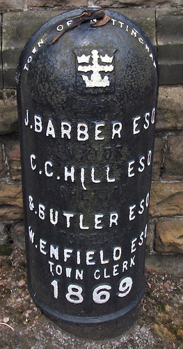
The most interesting site along this road were a couple of cast-iron boundary markers from 1859: these list the mayor and town clerk of the Town of Nottingham (it didn't become a city until some time later). In style they are very similar to the markers used when the City boundaries were extended in the 1930s (see an earlier post). I was intrigued because I didn't know which area was on the other side of the boundary. Fortunately we have an old map at home (Salmon's map) which is virtually contemporaneous with these boundary markers. I took a couple of pictures of the same area that we walked through showing the state of Nottingham in the early 1860s. This clearly shows the boundary, and that Mapperley Park and much of the Forest were in the parish of Basford. Basford was incorporated into Nottingham in the 1880s.
Also of interest is that the road was then called Red Hill Lane. Some road names in St Anns have been preserved although in altered form after re-development, but quite a few on the roads around Bellevue Reservoir seem to have been lost. It's not clear what name the paths round the reservoir have themselves: this old map calls it St. Anns Hill, which now belongs to a road which was then called Blenheim Villas, whereas modern maps (and some from the 1930s) name it as part of Corporation Oaks.
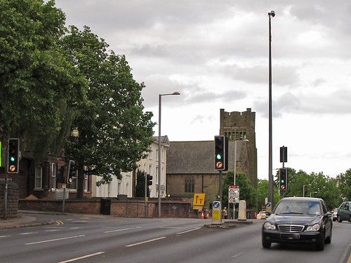
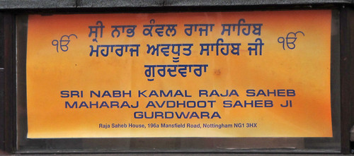
Returning to the pub along Mansfield Road we had a better look at the prominent church shown at the top of the blog. Paul had noted that it seemed to be a Gurdwara, a Sikh Temple, and as we passed it took a 'photo of the notice board. The following day I felt compelled to do a bit of research: How long had it been a Gurdwara? Who built it? what was it's recent history? I was relieved to discover that it had recently been acquired from the Christian Scientists who have moved their place of worship into their fine office building next door. But originally it was built as a Presbyterian church. So it had been a church when first mapped on OSM, but another object lesson that things ain't what they seem and the importance of ground surveys.
We ended up in the snug at the Poacher for a pie (Paul) and several pints.
Stanage Edge, Derbyshire The site of hundreds of hyperlocal names used by rock climbers. Photo courtesy of Earthwatcher BY-NC-ND
We had an interesting a discussion in March on the OpenStreetMap talk-gb mailing list arising out of some controversial naming practices in Loch Lomond and Trossachs National Park ("Giro Bay"). Someone suggested that no-one would or should ever add newly minted names on OSM.
This is an extended version of why I think that names widely recognised in specialist communities should be used when appropriate. I call these names "hyperlocal", because many of them are used for naming features or localities which non-members of the relevant community would not recognise, or would see no need for naming them.
Naturalists. This whole post started because someone expressed surprise that 'non-official' names might be entered in OpenStreetMap (all my examples are from Attenborough Nature Reserve, Nottinghamshire). Naturalists, and particularly those managing and using nature reserves, are creating new names all the time. In part this is because often these places themselves are new (for instance old industrial workings and quarries — "The Delta", "The Bund"), but mainly because much greater precision is required for location information. This is really important if one wants to find the only example of a rare plant, or check on a bird-box location, or photograph a rare fungus, or make sure the right tree gets chopped down. Also one becomes increasingly aware of minor differences which dramatically affect the range of plants and animals over a small area. In principle this could be communicated by using grid references and at a fine scale a GPS. In practice names are more memorable, help to delineate areas which grids don't, and are much easier to communicate. Some names stick, others may be concocted but never enter common usage. Some places have multiple names, and it takes a long time to find a consensus ("Old Car Park", "Fishermans Car Park", "Education Meadow", "Corbett's Meadow"). Many names have multiple intelligible variants ("Butterflies", "Butterfly Triangle", "Butterfly Patch"). In other cases it's possible to see how a name changes. For several years charcoal has been made at Attenborough: the area by the kiln is now nearly always referred to as "by the Kiln", whereas it used to be called "Redwings". In other places locations are known by number alone, for instance 'compartment 73'. I have a map of compartment numbers for Clumber Park, but it's an internal National Trust document, they are used in the national Fungal Records database though.
I have added several of these 'made-up' names which are in common usage around Attenborough Nature Reserve: the Delta, Warbler Dell, Dirty Island Bank, Butterfly Patch (in use since the 1960's), Corbett's Meadow (a recent 'official' coinage, in memory of Keith Corbett who was reserve manager for over 30 years until his death in 2007), which is also known locally as "The Fisherman's Car Park", and "The Old Car Park", and Education Wood (a recent unofficial coinage, around 2005). As all the water bodies were created by gravel working, their names have evolved recently too. I have only added those which are in widespread usage: there are perhaps 50-odd names which were coined in the '60s and '70s, mostly eponymic toponyms, but many never caught on.
Carsington Reservoir is another location where local birders have evolved a significant number of toponyms. Any of the Helm "Where to Watch Birds" regional guides will provide many more examples.
Climbers. Hill and mountain areas are chock full of named features which might never be noticed. This isn't surprising, the cliff shown at the top of this post Stanage Edge has 100s of climbs along its length. The convention is that the first people to successfully climb a route have naming rights, but it's more complicated than that. An even smaller crag further S in Derbyshire, Birchen Edge, has a convention that climbs names should have a nautical allusion (Trafalgar Wall, Camperdown Crawl). I would think in Derbyshire alone there are probably well over 5000 named climbing routes. Many of these will be less than 20 m ascent. On the harder ones each hold will be memorable (I'm not yet aware of these being named yet). On the other hand some places fall into disuse. My father and his friends used to climb at Laddow Rocks because it was accessible by bus from the Manchester area. Much of Laddow is now mossy and green, but everything on it still has a name: several guidebooks were published.
Oddly, in bigger mountains such as the Alps there is not this degree of minutiae in naming: or if it exists it's not published so widely. A number of factors influence this. Climbing in the Alps tends to follow obvious lines because there are a lot more of them, and they're much longer. Sport climbing has used pictorial 'topos' for a long time, so they avoid the same need for names as a narrative descriptive system. There are still plenty of these names though, the Eiger Nordwand has lots, all used in many mountaineering books, and giving a title to one: Hinterstossier Traverse, The White Spider, the Third Ice Field, Traverse of the Gods, Exit Cracks and so on. That is just one face of one mountain, albeit a famous one, and there's enough variety in the type of names to give a feel for how they were created.
Skiers are another group who go into the mountains for recreation. In many ski resorts many of the names are invented and often follow a stereotyped pattern typically with lots of alpine fauna: White Hares, Pika, Marmots, Chamois, Ibex, Ptarmigan. The older European resorts still use lots of names which arose naturally from older uses.
St Anton in the Tirol has many ski runs and locations named after alpine meadows. Some of these, such as Gampen (often Gampli) have an interesting linguistic history indicating the presence of speakers of a latin-derived language in the area similar to modern Romansch. Mattun, is another name ultimately derived from latin, referring to a characterstic member of the mountain vegetation. Both of these are fairly common place name elements close by in the Eastern Graubünden. (Place name etymology from the Swiss Alpine Club guides). In addition to the regular runs, St. Anton has a host of well-known, named, off-piste runs. The photo shows the top of a broad but steep gully off the Schindlerspitze: but, I never learnt the names of these gullies. Some of the seriously steep chutes have names which are closely guarded secrets passed on only to those who have skiied them.
On the Grands Montets many apparently non-obvious features have names (often different names in different languages): Combe des Amethystes or the Italian Bowl; Canadian Bowl. Again these are not to be found on maps, but are widely used by people who know the area. One or two specialised publications use them too. It's possible to ski a line a few metres from the Italian Bowl and not be aware that its there: even then finding the direct entry which gives an exhilarating steep start requires precise knowledge of the local geography. So once again, these names have arisen from a need for much greater precision than might otherwise be expected.
Ski racing requires a heightened awareness of terrain which again tends to drive increasing precision in naming. One of the oldest open downhill races in the Alps is the Parsenn Derby. When I first visited Davos the piste which formed the lower part of the course had markers giving the names of each turn and schuss. nowadays the course is shorter still, but still features places like the 'S-bends' and the 'Derby Schuss'. It's not for wimps like me:
Motor Racing. Any one who has followed a Grand Prix will know that every part of the track has a name. Of course on a modern track these names will have been invented and assigned by marketeers, but on courses with a long history, like Silverstone, it's easy to guess how the names came about. Early users probably said things like 'I came off at the corner near Stowe', which being cumbersome would get rapidly shortened to Stowe Corner. Of course names were useful to everyone: drivers, instructors, marshals, commentators and spectators. Now they integral to what people expect of a motor racing track. Many of these are captured on OSM, including the circuit featured on Top Gear.
Fishing. I know little about fishing, but it struck me that fishermen must have names for favourite spots, and then I came across the wonderful annotations of Walking Papers by Kirk Lombard. The one I show above is near Fishermans Wharf, San Francisco, with one fisherman's name "Striped Perch Hole". Incidentally, this seems to be a great example of using Walking Papers (and OSM) in an innovative and unexpected way.
Names seem to evolve in each of this situations in similar ways. Often they are created by pragmatic shortening of a description. Memorable events, and the people associated with them, are another rich source of names. Things also get named after people as a token of appreciation, respect or a with to remember them. Thematic naming sometimes works, but often ends up being insufferably twee, and is often resisted or subverted, particularly by wit.
One last one example are local names to the swimming holes on Fairham Brook by Keyworth Meadow NR: see Neil Pinder's article on the parish website. I've asked around for other examples, and someone with extensive experience of forestry noted that workers named landscape features in a very similar way to naturalists I'd be very interested to hear of other examples, particularly outside the interest domains I've covered in this post.
The ability to map these hyper-local toponyms is a very attractive part of OSM. Of course, they need to be researched accurately to ensure they are names which are used rather than 'book-names'.
Not cute animals or vicious pests, but PersistentOpen Streetmap Unique MapIds!
I've been intrigued by the idea of creating persistent IDs for geographical objects in OSM for a while. Although things in OSM do get a unique ID there is absolutely no guarantee that a given object will retain a single ID, or that a given ID will not be used for multiple objects over time. A classic example is the pub initially mapped as a node, then with a building outline traces, and finally the tags are moved from the node to the building and the node deleted.
Persistent IDs would make it much easier to link external data sources to OSM data. It may obviate the need to add certain types of data directly to OSM. SteveC pointed out the problem of business names in a comment on another post here.
The basic problem is conceptually not too difficult: I've done similar things with bank customer and account data. In a typical business application the problem is, however, that although individual systems usually have persistent IDs there is no single one which links across systems (imagine say multiple bank accounts, a credit card and an insurance policy). With OSM we don't even have this luxury.
My basic notion would be to choose something like the minimum node ID of an object when it is first created and use that as a reference throughout its OSM life-cycle (including, potentially, several deletion and restoration events). Some kind of collision avoidance is needed for objects which share nodes, and handling of certain border cases of ways sharing all their nodes and some types of relations).
Each time an object is touched in a changeset a process is needed to determine what happens to its persistent ID. In most cases nothing will have affected it, but it may be difficult to ensure that these cases are identified. In general geometry changes are unlikely to have an impact whereas changes in topology will: but, I don't know what one should do in the case of inaccurately mapped objects which change position significantly. Changes in topology may result in logical merges and splits of objects previously regarded as atomic, so I imagine the relationships between POSSUMs will need to be stored. Consider a road segment (A->B) between two junctions which gets edited and an additional junction is added between the two (A->C->B): two new identifiers need to be created for A->C and C->B which are children of the original A->B.
Here'a s list of other characteristics, in no particular order, which I think they should possess:
I think POSSUMs should be approached as an enabling technology: there may be many different persistent ID schemes depending on individual use cases. Some people may be interested in the road network, others might be interested in building outlines, or it might be a specific geographical area, and so-on.
POSSUMs therefore should be independent of the OSM data infrastructure: of course if they proved very useful then OSMF might want to provide them as a service.
POSSUM creation needs to be rule based: starting rules will be based on tags, and some aspects of geometry (e.g., road junctions).
They need only cover a subset of data. New subsets should be capable of being added to an existing POSSUM data store (the cage?).
It should be possible to add history of elements retrospectively and a pre-existing POSSUM to be used to identify the older versions of an element.
POSSUMs would only be created for tagged objects (excluding things like fixme, note, source etc.)
POSSUMs and OSM objects would have a many-to-many relationship. Some means of identifying parts of a way (e.g., road segments), and POSSUM roles will be required (e.g., pub as premises or building, pub as business).
Relationships between POSSUMs may require some manual maintenance.
Applying changes to rules means they also need to be applied retrospectively, thus some POSSUMs will be superseded (just as in the new junction case). This is probably technically the most complex part of the idea.
The primary use case for POSSUMs is for the maintenance of linkages between external data (e.g., public open data) and OSM objects in a way which minimises the amount of external data which needs to be imported into OSM. This in turn should reduce the maintenance overhead of keeping OSM data in sync with external sources.
POSSUMs might also be useful for OSM mappers when frequent uploads to the planet database are impossible. This commonly occurs in third-world countries, but also in crisis mapping and disasters when telecom resources are unavailable. At the moment mapping in this situation can give rise to large numbers of conflicts which are difficult to resolve. Use of persistent IDs might make the conflict resolution process easier. Aaron Cope has already done some much more sophisticated thinking for the use case of a worldwide building register. Check out his building=yes site using WOEIDs. I am sure there are others thinking about this: let's get the discussion rolling.
I'm grateful to Bob Chell of 1-spatial for a brief discussion of the basic notion at SotM10, Girona. This encouraged me to believe that the idea was not completely barking mad. But any remaining nuttiness is entirely my own.
SK53 received a Garmin GPS as a Christmas present in 2008. Foolishly he downloaded OSM, noticed a nearby street was missing, and promptly sold his soul to mapping. Since then he has mapped large parts of Nottingham, verified about half of Maidenhead, takes a PC on holidays for mapping, and now has 2 more GPS gadgets, but still feels the need for more. Further details on his OSM wiki page User:SK53
 The most interesting site along this road were a couple of cast-iron boundary markers from 1859: these list the mayor and town clerk of the Town of Nottingham (it didn't become a city until some time later). In style they are very similar to the markers used when the City boundaries were extended in the 1930s (see an earlier post). I was intrigued because I didn't know which area was on the other side of the boundary. Fortunately we have an old map at home (Salmon's map) which is virtually contemporaneous with these boundary markers. I took a couple of pictures of the same area that we walked through showing the state of Nottingham in the early 1860s. This clearly shows the boundary, and that Mapperley Park and much of the Forest were in the parish of Basford. Basford was incorporated into Nottingham in the 1880s.
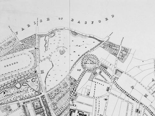


